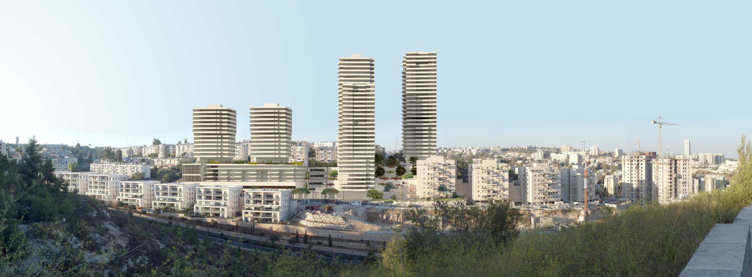
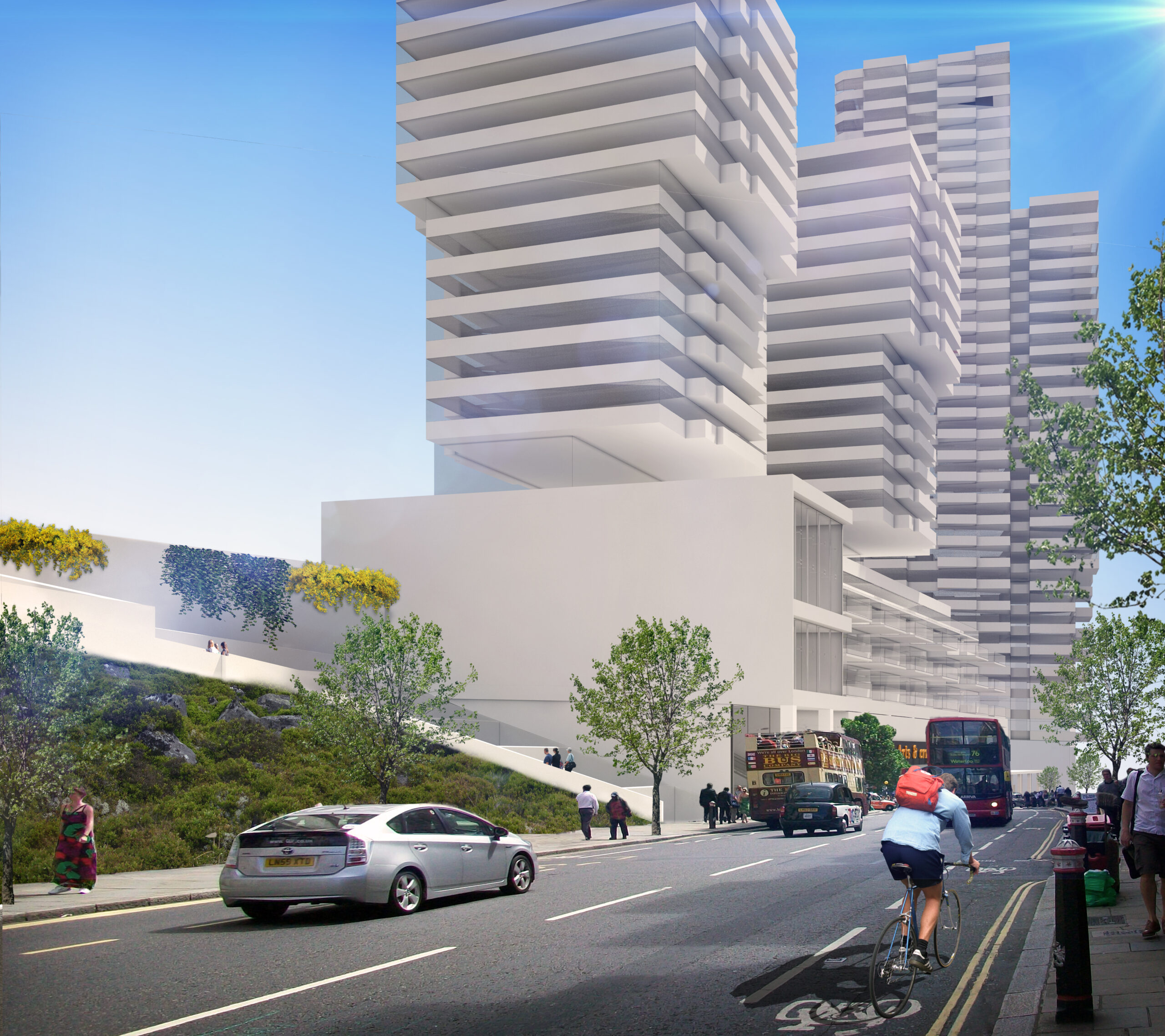
PELE “Park View” – Yuval Ganim, Jerusalem – urban renewal
The planning of an evacuation complex is very similar in complexity to the planning of a neighborhood, and unlike neighborhood planning it is necessarily not ‘anonymous’ and addresses an existing population and needs that are known in advance, on urban land in various degrees of development or neglect.
The ‘Park View’ program deals with urban renewal in the Ir Ganim neighborhood in Jerusalem, in an area of 12.5 dunams. The treated structure is old housing buildings from the 1950s. There are 3 “Rabat” housing buildings in the complex, on a narrow and long lot built on Mt. The existing one is elderly and of poor means. The complex is a union of several lots. The developer of the plan has a commercial lot with an area of about 2.5 D included in the plan, to which the Jerusalem Municipality applied with a request to attach the area to the vacant railway construction project. allowing for “construction first”, and for residents to move to the residential tower before the demolition of the housing buildings.
The design combines towers, creating a commercial urban texture and squares that refer to the two streets Noorit and Costa Rica to create an urban street, and solving the accessibility between the two streets, which are at a considerable height difference of 20 m. In the complex, plots with public designation for kindergartens, a synagogue and areas for the community were integrated, as well as the entire area of the SDF that was attached to the plan was returned. The combination is made possible through residential density and the design of tall towers and buildings.
The plan was designed for a general density of 32 units and a plot density of 67 units. Density in vacant built complexes is necessary. It is appropriate that a density calculation be done on the entire complex, as a benchmark for vacant built planning, and not on the individual lot.
The plan is groundbreaking in its treatment of complex social aspects, the conversion relations between the existing and the proposed, the density relations, the construction of towers in the southwest of Jerusalem, the integration of private lands, state lands (RMI) and municipal lands of the Jerusalem Municipality. The cooperation between the developer and the residents throughout the planning stages, and the activation of planning mechanisms that support the integration of the existing population in the renewed complex, such as a commitment to pay maintenance fees, a variety of types of residential buildings for the tenants to choose, legal support, etc. The plan received unprecedented support from the residents of the complex.
———————-
A plan for the construction of a 100-unit eviction in 3 buildings on Nurit Street, in old housing estates and small apartments. The blue line delimits 12.65 dunams, in the southern part of “Givat Nurit” in the Yuval Ganim project, in a very steep topography, 33% slope (20 m difference between the streets)
The plan proposes the construction of 2 residential towers, at a height of 22-25 floors above the lobby floor, a commercial center between Norit and Costa Rica streets, and special residences by the commercial center, at a height of 12 floors.
Areas for the public are also planned: kindergartens, dormitories, a synagogue, areas for the community, community center and community center.
The plan stipulates the construction of building A because there is an existing building, in order to allow the construction-evacuation process to start, and the occupancy of some of the residents, before the demolition of existing buildings.
The proposed plan includes 1,486 square meters of areas designated for public needs and 2,427 square meters of areas designated for public housing, and 1,770 square meters for private open space. (In the existing situation plan, 1,106 square meters of areas designated for public needs and 2,461 square meters of areas designated for public housing are included)
The plan creates a union between the areas of existing residential lots, a total of 3.4 dunams, area development and area for a public building, in an area of 5.6 dunams and their redistribution so that open public space and areas for public buildings will not decrease.
In the plan, a commercial center is planned on 4 levels, including a supermarket, a row of shops on Costa Rica Street and a commercial square on Norit Street. The center connects Norit and Costa Rica streets, and allows connection via elevators, escalators and stairs.
The plan produces an urban texture that refers to Costa Rica and Norit streets and creates an urban street.
Costa Rica Street includes a commercial arcade, a public garden, entrances to building B, and access to public buildings.
Norit Street is planned with open spaces along its length, a central square connecting to a central garden that is a window to the view. Along the street and the buildings is a public arcade, from which through the public buildings the street is connected by an elevator and ramps to Costa Rica Street.
The plan is a focal point for attracting a new population to the place, a solution to the problems of the old housing buildings, for small apartments for vulnerable populations, and a lever for construction-evacuation plans in southwest Jerusalem.